Conquering the Cumbria Way: A Solo Adventure through the Heart of the Lake District
Nathan, my partner, first noticed the Cumbria Way when out exploring new trails after we moved to the area and before long, we were regularly running along the South section from the shoreline of Coniston, up to Beacon Tarn and across farm fields into Ulverston. He was eager to run the full 73 mile route over a weekend, take a bivvy and camp out before heading home on a train from the finish at Carlisle – but as is often the way, life took over and a lot of summer was spent up in Scotland running on the Southern Upland Way (another fantastic long distance trail) ahead of Race Across Scotland in August – so he never got round to it. Summer started to fade and as my legs and mind recovered from our Scottish adventures, I was itching for a new challenge.
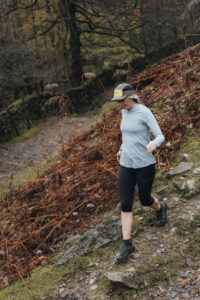
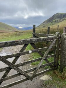
In the Lake District we are spoilt for choice when it comes to trails, routes and rounds, all equally steeped in fell running folk lore and usually with a long list of legends who have trod the ground before, it felt fitting to give one a go, given we now live here – Cumbrians in training. After poring over maps, it caught my eye, ‘The Cumbria Way’ contouring its way up the paper and I thought yes, that’s it, it was under my nose this whole time – not too challenging but challenging enough to give me the kick I was after! The Cumbria Way is a 73 mile national trail that’s typically travelled South to North from Ulverston to Carlisle, passing through Coniston, Langdale, Rosthwaite, Borrowdale and Keswick, with around 6000ft of elevation.

I also decided to do the route self-supported, meaning I was to be self-sufficient for the duration, aside from seeking water or food from shops or places that would be available to everyone. This added another layer of adventure and something I had liked the idea of doing for a while – a solo challenge, just me, myself and I, alone in the fells.
Planning the challenge was the first fun part, I love the mix of nervous energy and excitement that comes with doing runs outside of a race setting and project management is my forte. Given we were already in Autumn the first thing to iron out was the date, I settled for Friday 20th October just before the clocks changed. I worked out I’d have around 11 hours of light, with the sun setting by 6:30pm which felt manageable. I booked the day off work, planned to set off from Ulverston at first light, then could get a lift home from Carlisle whenever I arrived there.

That would also mean I had the whole weekend to laze around, eat and recover before heading back to work on Monday. Having already done my A, B and C races for the year, I was conscious of overdoing it, so before I went any further, I floated the idea past my coach, Paul Tierney, who compromised on letting me give it go – it was a weekend challenge, rather than a race after all. He also suggested that I run the route in reverse, Carlisle to Ulverston to avoid doing the dark night section along the potentially dodgy riverbanks of Carlisle alone (no offence to anyone who lives in Carlisle). I looked at where I could get water and fuel from, set a rough schedule and also borrowed a tracker off my friends at GB Ultras as an extra safety precaution and so family and friends could track me.
Like all great plans, I was forced to amend it before I even took the first step! Storm Babet hit the UK that week, with relentless rain forecast for Cumbria and wind gusts up to 69mph on the top of High Pike, the highest point on the Cumbria Way. I had no choice but to postpone the run. I kept an eye on the forecast all day and luckily Saturday was looking much better, and I made the call to set off at 7am from Carlisle on Saturday 21st October instead.

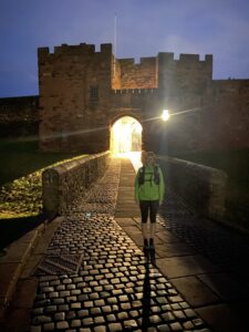
After forcing down a bowl of porridge at 4:30am, we bundled into the van with coffee’s and set off to Carlisle. A quick snap outside Carlisle Castle and I started my watch at 7am exactly – I was off! It was hard to get into a rhythm at first as all the rainfall had caused flooding along the riverbanks, so I spent the first 5 or so miles jumping over fallen trees and storm debris until I hit some more solid farm tracks after Dalston. The route then meandered along the river Caldew, through more boggy farm land until you reach some forest paths at Sebergham. By then the sun had risen and although it was cloudy, there was no rain in sight and the winds were mild – what a relief and instant gratification for making the correct decision to postpone the day before.
I stopped for my first water top up from a lovely coffee van in Caldbeck before beginning the biggest climb of the day up to the summit of the only Wainwright on the Cumbria Way, High Pike (2159ft). I barely saw another soul until I hit the claggy summit around 11am when I was greeted by a steady stream of hikers. The ground was getting increasingly boggier underfoot as I passed Great Lingy Hut on my way down Grainsgill Beck. It was frustrating and really slow moving but I kept trudging forward and eventually reached some solid ground a few miles below. Having never been on this part of the trail before, I was worried about navigation before the challenge, however, it was fairly easy going and the tracks were wide and clear on the stomp up to Skiddaw House. I enjoyed the solitude of being surrounded by the high fells with Great Calva towering above, my phone buzzed as I contoured around Lonscale Fell, it was Nathan checking in as apparently my tracker had dropped out after High Pike. Back on more familiar ground I headed into busy Keswick and grabbed a sandwich and more water from the local co-op, before sitting on the wall to take 5 and get some calories in.

The run around Derwent Water was beautiful and surprisingly quiet, I watched some people paddle boarding and swinging away in their hammock and did ponder why I chose to run such a long way, but then my watch ticked over 35 miles and I was delighted to be almost at the half-way point. With a renewed sense of purpose – although the slippery rocks slowed my progress slightly – I powered on to Rosthwaite. To my delight, I reached the village to find the café was still open and grabbed a much needed can of Coke – a sugar hit. I was conscious that I was starting to lose light and wanted to get up and over Stakes Pass before dark as it was unfamiliar ground.
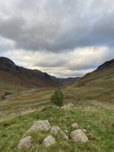
The valley through Borrowdale looked idyllic in the last of sun and I felt extremely grateful to be able to be free in such a place. My socks were soaked by this point and I’d started to get a hot spot on my heel, so I stopped before the climb to retape and layer up as the temperature had definitely dropped. Passing the grazing Herdwicks and over the pass, the views kept coming as I made my way down the rocky descent into Langdale. I think that section was my favourite part of the route. I pushed to hit the bunkhouse by nightfall, when it hit me that I’d now be in complete darkness for the remainder of the route – a thought I had been trying to shut out all day. In the Lakes there is little light pollution and with the moon cloaked in thick clouds, it really was pitch black. I refocused, pulled on my headtorch and another layer, all I needed to do was put one foot in front of the other.
Another water top up from the pub tap in Chapel Stile before meandering around Elterwater and into the woods past Skelwith Bridge, the light from my headtorch playing tricks on me as it reflected off tree branches, sending my imagination running wild, accentuated further by the amber glow of sheep eyes staring back at me. I hiked up to Tarn Hows and breathed a sigh of relief to reach civilisation in Coniston village on the other side. I nipped into the garage for my final restock – I was on the home straight.

My legs were starting to feel fatigued now and just as I reached the shoreline of Coniston, the heavens opened – lovely. I pulled on my waterproof over trousers in a bid to stay warm and dry and picked my way over tree roots, fallen trees and rocks, the darkness hindering my pace as I tried to stay upright in the wind and rain. Luckily, the weather eased off as I hit Torver Common and I felt confident route finding over familiar ground up to Beacon Tarn, jumping over bogs and weaving my way through bracken.
It was hard not to turn off down the lanes back to my cosy cottage, where I knew Nathan and our border terrier, Arthur would be hanging out dot watching. I caught my first glimpse of Hoad Hill Lighthouse in Ulverston and I knew I had about two park runs to go – this last section had taken me way longer than anticipated. Usually, the farm fields between Kiln Bank and Ulverston are full of cattle. It was something I’d been nervous of going into the run but by some miracle, the only animals I encountered were sheep, bunnies and deer. I legged it through the many farms, ignoring the barking dogs and got my head down as I waded through muddy fields, which seemed more churned up than usual after Friday’s storm. At 2am – an hour behind my original schedule – I ran into Ulverston town centre to the official start / finish point of the Cumbria Way, completing the 75 mile feat in 19 hours and 9 minutes – a new female self-supported record.
https://fastestknowntime.com/route/cumbria-way-united-kingdom
Article by Libbi McGibbon